
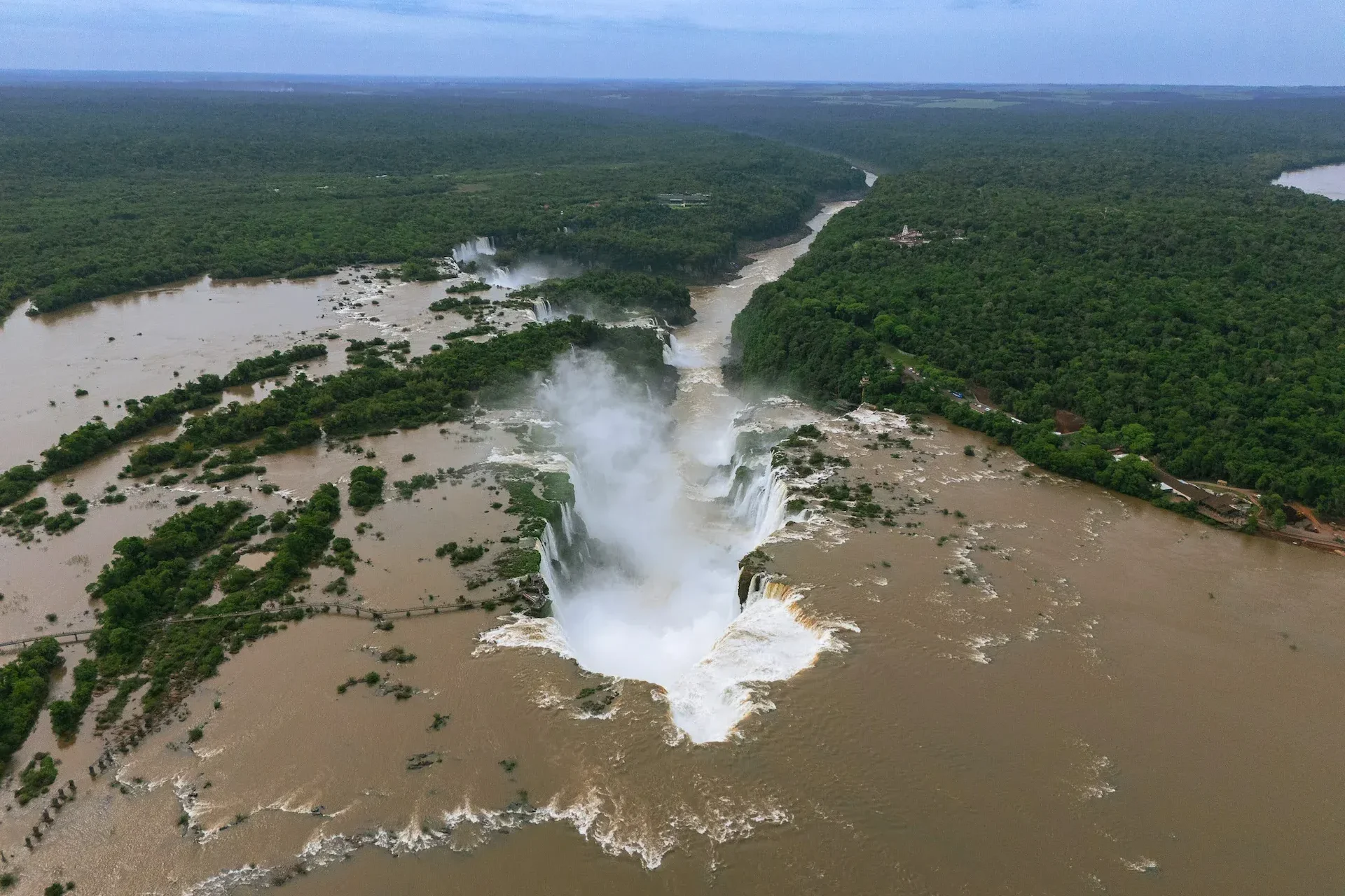
Iguazu Falls is usually described through superlatives: enormous, thunderous, spectacular and unforgettable. Yet its beauty is not accidental. Every major element of the landscape—the broad waterfall front, the stair-like cascades, the narrow Devil’s Throat, the dark cliffs, the reddish soil and even the arrangement of the river channels—reflects a geological history extending back more than 100 million years.
From a geological perspective, Iguazu is much more than a collection of waterfalls. It is an active landscape created through the interaction of continental-scale volcanism, tectonic fractures, river incision, rock weathering and repeated episodes of erosion.
The International Union of Geological Sciences identifies Iguazu as an important example of active geomorphology, volcanology and regressive river erosion. It also provides an unusually accessible place to observe rocks associated with the fragmentation of Gondwana and the opening of the South Atlantic Ocean. International Union of Geological Sciences
The geological story of Iguazu can be divided into two immense chapters.
The first was dominated by fire. During the Early Cretaceous, vast quantities of basaltic lava spread across what is now southern Brazil, northeastern Argentina, Paraguay and Uruguay.
The second chapter was dominated by water. Rivers crossed the volcanic plateau, exploited fractures in the rock and gradually excavated valleys, rapids, gorges and waterfalls.
The lava created the structure. The river revealed it.
This distinction is important because the volcanic eruptions did not directly produce the modern waterfalls. They created a thick, layered basaltic platform. Iguazu Falls appeared much later, after the regional drainage system began cutting into that platform.
The rocks exposed at Iguazu belong to the Paraná–Etendeka Large Igneous Province, one of the greatest continental volcanic provinces on Earth.
A large igneous province is formed when extraordinary quantities of magma reach or intrude into Earth’s crust during a relatively concentrated geological interval. Instead of building one familiar cone-shaped volcano, many of these eruptions release lava through extensive fissures.
The result is not a single volcanic mountain. It is an enormous lava-covered plateau.
Modern geochronological research places the principal Paraná–Etendeka volcanic activity broadly in the Early Cretaceous, with a major concentration around 135–120 million years ago. Exact ages vary among rock units and dating methods. The province is recognized as one of Earth’s largest continental flood-basalt systems. Geochronology of the Paraná–Etendeka Large Igneous Province
In South America, the volcanic sequence is commonly grouped within the Serra Geral Formation or Serra Geral Group. Across parts of southern Brazil, the volcanic pile approaches approximately one kilometre in thickness and includes numerous distinct lava packages rather than a single eruption. Serra Geral lithostratigraphy and volcanology

Experience the wonder of Iguazu Falls on a private 2 day tour from Buenos Aires. Easily reserve accommodations and optional activities. Book now!
From Price: USD150
When the Iguazu basalts erupted, South America and Africa had not yet reached their present positions. Both formed part of Gondwana, the southern portion of the earlier supercontinent Pangaea.
As the continental crust stretched and fractured, magma rose through long fissures. Repeated eruptions covered older landscapes with broad sheets of lava.
Eventually, the continents separated and the South Atlantic Ocean opened between them. Volcanic rocks related to the same immense magmatic system now occur on both sides of the ocean:
Their present separation is the result of continental drift. They are geological counterparts—fragments of a volcanic province that formed before the Atlantic divided Africa from South America.
When visitors stand beside Iguazu Falls, they are therefore looking at evidence of a tectonic event that helped reorganize the geography of the Southern Hemisphere.
The volcanic rocks did not erupt onto a landscape resembling the modern Atlantic Forest. Before the main lava eruptions, large parts of the Paraná Basin experienced desert conditions.
Wind accumulated enormous deposits of sand, later transformed into the sandstone of the Botucatu Formation. Some lava flows spread directly across this ancient desert surface. In places, sand was trapped between volcanic episodes, producing sedimentary layers within the larger lava sequence.
This geological relationship is significant because the Botucatu sandstone became part of the Guarani Aquifer System, one of South America’s most important groundwater reservoirs. The overlying basalt influences how water enters, moves through and emerges from the regional subsurface.
The Iguazu region thus preserves traces of very different environments:

Enhance your visit to Iguaçu National Park in Brazil and experience a breathtaking sunset at Iguazu Falls with a delightful drink in hand.
From Price: USD139
A basalt flow is not structurally uniform from top to bottom.
As lava spreads and cools, different parts of the flow develop distinct textures.
The central portion of a thick flow cools more slowly. It commonly becomes dense, dark and relatively resistant massive basalt.
Where extremely hot lava encounters the older ground surface, rapid cooling may create fractures near the base.
Gases escaping from the lava create cavities called vesicles. As a result, the upper part of a flow may be more porous and irregular than its dense interior.
The boundary between two eruptions may contain broken volcanic material, weathered surfaces, sediment or zones of greater permeability.
These variations are fundamental to the appearance of Iguazu Falls. Water does not erode every portion of the volcanic sequence at the same rate.
One single amazing destination, three different countries!
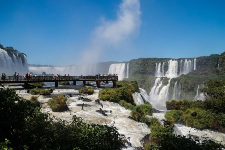
The word “traps,” used for some flood-basalt provinces, comes from a Scandinavian word associated with stairs or steps. This is an appropriate description of Iguazu.
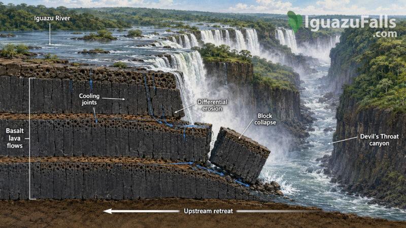
Geological studies describe three principal lava layers exposed around the falls. Contacts between flows, together with differences between massive and vesicular basalt, help produce the characteristic stepped profile.
At some locations, water descends in two major stages rather than making a single uninterrupted plunge. Research describes central sections with drops of roughly 35 and 40 metres, reflecting the resistant portions and contacts of the volcanic sequence. “Iguazu Falls: A History of Differential Fluvial Incision”
This process is known as differential erosion:
The waterfall is therefore maintained not because basalt is indestructible, but because different parts of it fail at different rates.

When lava cools, it contracts. This contraction creates fractures known as cooling joints.
In massive basalt, the joints may form prismatic or column-like structures. They are not necessarily as regular as the famous columns of places such as the Giant’s Causeway, but they divide the rock into natural blocks.
The Iguazu basalts contain both vertical and horizontal fractures. Some developed during cooling; others were influenced or reactivated by later tectonic stresses and by the removal of overlying rock.
These fractures give the river ready-made lines of weakness.
Water enters the joints, widens them and increases pressure within the rock. Plant roots, chemical weathering and repeated wetting also contribute to weakening. Eventually, entire basalt blocks can separate and collapse.
This process helps explain why the cliffs may appear strikingly vertical. The rock does not always wear away grain by grain. It can fail suddenly in large, joint-bounded pieces.
The direction of the Iguazu River and the geometry of the waterfall front are not controlled by erosion alone.
The basaltic plateau contains faults, joints and regional lineaments—long structural features reflecting deformation of the crust. Sections of the Iguazu and Paraná river systems appear to follow these zones of weakness.
Above the waterfalls, the Iguazu River spreads broadly across the plateau and flows among islands and basalt outcrops. Near the falls, it changes direction and becomes concentrated into a much narrower canyon.
This abrupt reorganization suggests strong structural control. Rather than cutting randomly through uniform rock, the river has exploited fractures and fault-related weaknesses.
The curved and irregular arrangement of individual waterfalls also reflects the intersection of:
The shape of Iguazu is therefore a geological map expressed through moving water.

Enjoy a city tour in Puerto Iguazu, to visit differnt areas and views of the river, and the famous triple frontier landmark
From Price: USD75
The Devil’s Throat—Garganta del Diablo in Spanish and Garganta do Diabo in Portuguese—is the most dramatic expression of the erosional system.
Here, a large proportion of the river is funnelled into a narrow, deep, horseshoe-shaped gorge. Instead of spreading evenly across the entire waterfall front, the water converges into a confined zone where erosional energy is exceptionally high.
The gorge below the Devil’s Throat is approximately 70–80 metres deep and locally around 80–90 metres wide. It continues downstream for roughly 20 kilometres toward the confluence of the Iguazu and Paraná rivers, although published measurements vary depending on the limits used. Differential fluvial-incision study
The Devil’s Throat is essentially the active head of this canyon. It marks the place where the river is continuing to extend the gorge upstream.
Waterfalls are not permanent walls fixed in one location. They are migrating landforms.
At Iguazu, erosion at the base of the falls undercuts the basalt. Fractured blocks eventually collapse, causing the edge to move slowly upstream. This is known as headward or regressive erosion.
The long canyon between the present waterfalls and the Paraná River is interpreted as evidence of this retreat. According to a widely cited geomorphological model, the falls may once have been much closer to the confluence of the two rivers.
One study estimated an average retreat rate of approximately 1.4–2.1 centimetres per year over the last 1.5–2 million years. However, this should not be imagined as smooth annual movement. The study also emphasizes that there are no direct absolute ages for the complete evolution of the river system.
Actual retreat is likely episodic:
The published rate is therefore a long-term geological estimate, not a prediction of annual cliff movement.
Buenos Aires, Iguazu, & Rio de Janeiro: A Triad of South American Splendor

A useful geological distinction is the difference between the age of the rock and the age of the landform.
The basalt beneath Iguazu is around 130 million years old. The modern waterfall system is much younger, probably developing during the late Cenozoic and evolving significantly during the Quaternary.
This means that the rock platform existed for tens of millions of years before the present canyon and waterfall front emerged.
Saying that “Iguazu Falls formed 130 million years ago” is therefore misleading. The volcanic foundation is that old; the waterfalls themselves are products of a much later river history.
Visitors traveling through Misiones Province often notice the intensely red soil.
This color is closely related to the chemical weathering of basalt under warm and humid conditions. Basalt contains iron-bearing minerals. Over long periods, water and oxygen transform these minerals, producing iron oxides that give weathered rock and soil their red, orange and brown colors.
The transformation from dark basalt to red soil illustrates how tropical weathering can alter a volcanic landscape.
Under the forest, this weathering produces a deep regolith—the layer of altered material above fresh bedrock. On exposed cliffs, dark or gray basalt may remain visible, while surrounding slopes display reddish weathered surfaces.
After intense rain, fine sediment washed from the basin can turn the Iguazu River brown or red-brown. This color does not mean the waterfalls have changed chemically; it usually reflects the transport of suspended soil and sediment.

The gas cavities in the upper portions of lava flows did not always remain empty.
Mineral-rich fluids later circulated through the rock and deposited crystals inside some vesicles. These mineral-filled cavities are known as amygdales or geodes.
The wider Paraná volcanic province is famous for minerals including:
Some are commercially extracted elsewhere in southern Brazil and neighboring regions. Their presence records a stage after the lava solidified, when groundwater and hydrothermal fluids moved through fractures and cavities.
Collecting rocks or minerals inside either national park is prohibited. Their value at Iguazu is scientific and educational: they are part of the protected geological system.
The geology establishes the form of the cliffs, but hydrology determines how that form is displayed.
During periods of high discharge:
During lower water:
This is why Iguazu can look radically different from one visit to another. The rock architecture remains broadly the same, but the visible pattern of water changes with rainfall across the watershed.
One single amazing destination, three different countries!
The forest surrounding Iguazu is not separate from its geological foundation.
Basalt weathering contributes minerals to the soil. Topography controls drainage, while fractures influence groundwater movement. Waterfall mist produces permanently humid microenvironments on nearby cliffs and islands.
The canyon also creates:
The waterfall acts as a biological barrier as well. Aquatic species living upstream may be separated from those below the falls, influencing the evolution and distribution of fish and other organisms.
Geodiversity—the variety of rocks, soils, landforms and physical processes—supports biodiversity.
No. Iguazu Falls is not the crater or remains of one large extinct volcano.
Its basalt was produced by extensive fissure eruptions distributed across a continental-scale region. The volcanic sources were not centred beneath the modern waterfall.
There is also no active magma system beneath Iguazu associated with the ancient flood-basalt event. The processes shaping the modern landscape are principally:
The landscape is geologically active, but not volcanically active.
Enjoy a city tour in Puerto Iguazu, to visit differnt areas and views of the river, and the famous triple frontier landmark
From Price: USD75
Visitors do not need specialized equipment to recognize the geological story.
The panoramic trail offers the clearest overall view of the waterfall front. Look for:
The upper and lower circuits provide closer views of the rock-water relationship. Look for:
Observe the contrast between the broad upper river and the narrow gorge. This dramatic change in geometry illustrates how the channel becomes focused along a zone of structural weakness.
DISCOVER A WONDERFUL PLACE TO ENJOY BIRDWATCHING. BE READY WITH YOUR BINOCULARS.

Iguazu Falls will continue to change.
The cliffs will retreat upstream as water removes fractured rock. Individual cascades will shift, merge or disappear. New channels may capture greater portions of the river, while others may receive less water.
At geological timescales, the canyon will lengthen and the waterfall front will migrate. If erosion continues long enough, the falls may become lower as they encounter different rock levels or as the river profile becomes more gradual.
This transformation will not happen on a scale visible during an ordinary human lifetime. Yet major floods and individual block collapses can produce shorter-term changes.
The apparent permanence of the waterfall is therefore an illusion created by our limited sense of time.
UNESCO describes the river as dropping as much as approximately 80 metres across a front nearly three kilometres wide. The Argentine and Brazilian national parks protect not only the waterfall’s scenic beauty but also one of the most important surviving portions of the Interior Atlantic Forest. UNESCO: Iguazú National Park and UNESCO: Iguaçu National Park
But geology reveals a deeper reason for Iguazu’s importance.
The site connects several scales of Earth history:
Iguazu Falls is not simply water falling over stone. It is a place where ancient volcanic architecture is being actively dismantled by a modern river.
The roar of the Devil’s Throat is therefore the sound of a landscape still under construction.
Experience the wonder of Iguazu Falls on a private 2 day tour from Buenos Aires. Easily reserve accommodations and optional activities. Book now!
From Price: USD150
Experience the awe of Iguazu Falls on a 3-day tour from Buenos Aires. Book now for an unforgettable adventure!
From Price: USD150
